What is a physical map?
A physical map aims to depict and mimic the terrain's physical characteristics. Any part of earth can be represented in this map
A physical map aims to reproduce all the visual data concerning the terrain. . Even in a 2-D shape, that is in a paper format, they clearly depict geographical elements. If someone wants to utilise a paper map, Physical Maps are the finest source to understand a terrain. Physical maps can do this with the help of colours and keys. Features like the elevation of the land, significant borders, waterbodies, and deserts are prominently displayed, which is very important.
What are features of a physical map?
Essentially a physical map shows mountains, plateaus, plains, islands, deserts, rivers, oceans and lakes. They are shown using colours and shadesIn many physical maps countries and major cities are also marked, but these are not the major focus of a physical map.A physical map is used to understand the topography of the place and it essentially represents how the land looks in the natural form. Political divisions are not a major focus in the physical map
How do you identify a physical map?
The natural features of the world, such as mountains, plateaus, plains, rivers, oceans, etc., are depicted on a physical map. Relief maps are another name for physical maps.
Physical maps show a location's physical attributes, which can be distinguished using the symbols in the map's legend or key. Contoured lines are used on topographic maps to depict elevation variation. This is different from a globe. The Globes depict the earth as a sphere, just as it is.
What is a physical map of India?
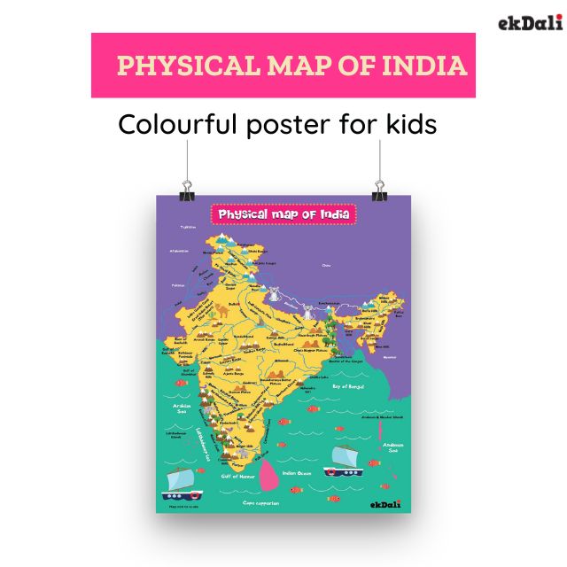
All of India's geographical divisions are depicted on a map of the seventh-largest nation in the world. The country has a wide range of topographical features. You can grasp all of India's topographical characteristics with the help of our educational physical map of India. The nation is made up of mountains covered in snow, hills, broad plains covered in greenery, deserts, forests, rivers, plateaus, and seashores. There isn't a physical characteristic that India doesn't have.
Physical map of India for kids
Teachers, parents, and children can benefit greatly from having access to a phycial map of India. You can buy the physical map and kids can use it for map pointing. They will have more knowledge of India's geographical characteristics. Using the physical map of India, they can easily find the physiographic or Geographic regions of India
How many geographic regions are in India?
India has 6 main geographic regions or physical divisions
The Himalayas, the Northern plains, the Great Indian desert, the Peninsular Plateau, the Coastal Plains, and the Islands.
Let us dive deeper into some of the most striking and beautiful features of India
In the Physical map you will see that we have marked many different features of India,
Here are some cool facts about some of these physical divisions of India
The Himalayas or the Northern Mountain Ranges:
The Himalayas are made up of at least three separate ranges that are roughly parallel to one another rather than a single range.\
The Great Himalayas' formation marked the beginning of the first phase about 50–40 million years ago. About 30 million years ago, the Great Himalayas were fully formed.
About 25–30 million years ago, the Middle Himalayas were formed, marking the beginning of the second phase.
The Shiwalik Mountains were created during the final stage of the Himalayan orogeny, which occurred between two and twenty million years ago.
The Tibetan plateau also has some of the fossil formations that may be found in the Shiwalik Hills.
The Himalayas cover many of the Northern and the North Eastern states of India. The Himalayas can be further divided based on the regions in which they exist into the following 5 divisions
The Kashmir Himalayas :
Ladakh , Pir Panjal, Zaskar and Karakoram are part of this. The Kashmir valley is part of this region. This region contains karewa formations which is great for growing Saffron. Jhelum and Chenab main tributaries of Indus river r flow through this area of the Himalayas.
The Himachal and Uttaranchal Himalayas:
The Indus and Ganga river system drain here. The Himalayas itself as a geological phenomenon formed in 3 separate phase
Darjiling and Sikkim Himalayas:
This is located in Bhutan's east and the Himalayas of Nepal's west.The area's river, named Tista, moves quickly.India’s highest peak the Kanchenjunga Peak (Kanchengiri) is located in this range. The distinguishing characteristic of this region is the absence of Shiwalik formations. They have been replaced with "duar formations," which are beneficial for growing of the tea gardens.
Arunachal Himalyas.:
Significant mountain summits include Kangtu and Namcha Barwa. Brahmaputra travels across Namcha Barwa before entering a small gorge. Due to the rough geography the transportation links between valleys is very minimalThis region also has no Shiwalik formations.
Eastern Hills and Mountains:
They cover an area of around 37,900 square miles in the North eastern states, Mostly Arunachal Pradesh, Nagaland, Manipur, Mizoram, Tripura, and eastern Assam
The Northern Plains
The Northern Plains are surrounded by the Shiwalik range in the north, the Desert in the west, the Peninsular Plateau in the south, and the Puruvachal Hills in the east.
The alluvial deposits of the Indus, Ganga, and Brahmaputra river systems and their tributaries are what give rise to India's northern plains. The Northern Plains are divided into sections that are roughly 2400 km long from west to east and 150–320 km long from north to south. India's Northern Plains have an area of more than 7 lakh square km. There is a sizable population due to the plentiful water supply, pleasant climate, and fertile alluvial soi
The Peninsular Plateau
The Peninsular plateau is a plateau made up of ancient crystalline, igneous, and metamorphic rocks. It is the oldest landmass and was created by the fragmentation and drift of the Gondwana continent. Large, shallow valleys and rounded hills make up the plateau. This plateau is divided into two main regions: the Central Highlands and the Deccan Plateau.
Between 300 and 900 meters high, the Vindhyas, Satpura, Mahadeo, Maikal, and Sarguja ranges separate this high plateau from the Indo-Gangetic plain.
It has a slope that runs from west to east and reaches into Rajasthan (in the west) and the Assam plateau (in the east). It is flanked on the west by the Sahyadris, also known as the Western Ghats, and on the east by the Eastern Ghats. Its overall area is close to 16 lakh square kilometers. Geographically, the peninsular uplands of India make up the majority of the nation.
The bio diversity of The Western and Eastern Ghats, which set the limits of the peninsular plateau, is extraordinary
The coastal Plains
The western coastal plains are along the Arabian Sea whereas the eastern coastal plains are located along the Bay of Bengal. They touch 13 States and Union Territories
The eastern coastal plain contains the deltas of the Mahanadi, Krishna, Godavari, and Cauveri rivers. The deltas are incredibly fertile and agriculturally productive. It stretches from West Bengal to Tamil Nadu. It passes through Odissa and Andhrapradesh
From Kerala in the south to Gujarat in the north, the Western Coastal Plains pass through Karnataka, Goa, and Maharashtra. Off the coast of Mumbai, the West Continental Shelf is at its widest. Oil is abundant in this area. There are numerous lovely lagoons along the Malabar Coast, which draws tourists to the area. Compared to the eastern coast, the western coast is narrower.
Islands in India
India has two main island groups: the Lakshadweep Islands in the Arabian Sea and the Andaman and Nicobar Islands in the Bay of Bengal.
They are of volcanic and coral origins
Please do check out some of the products that might interest you
Physical map of India for Kids
India Map with monuments for kids
India Map with Animals for Kids


